A project by Matthew Freeman

Habitat Locations

This page shows what it is like to live in low Earth orbit and at the lunar south pole, drawn from cited public sources.

v1.0 · November 2026Data as of October 2026

13habitats
9in Earth orbit
4on the lunar surface
44sources cited

Explore

Where the planned habitats will operate

Key: TBD = to be determined (no cited source states it) · calc. = calculated by us from cited inputs · † = low confidence · inclination = the tilt of an orbit relative to the equator. More are in Terms and abbreviations, under Method.

Ring spacing is schematic, not to scale. ISSOrbital Reef · ~500 km · 51.6°Haven-1 · 425 km · 51.6°Starlab Station · 500 km · 45°Bharatiya Antariksh Station · ~450 km · 51.5°†Haven-2: altitude and inclination TBDGravitics StarMax: altitude and inclination TBDThunderbird Station: altitude and inclination TBDAxiom Station: altitude and inclination TBDRussian Orbital Station: altitude TBD

Orbital Reef

Altitude (km)
~500 km1
Orbit tilt (°)
51.6°1
Time per orbit (min)
~94 min1,25, calc.

Haven-1

Altitude (km)
425 km43
Orbit tilt (°)
51.6°43
Time per orbit (min)
~93 min25,43, calc.

Haven-2

Altitude (km)
TBD
Orbit tilt (°)
TBD
Time per orbit (min)
TBD

Starlab Station

Altitude (km)
500 km33,34
Orbit tilt (°)
45°33,34
Time per orbit (min)
~94 min25,33,34, calc.

Gravitics StarMax

Altitude (km)
TBD
Orbit tilt (°)
TBD
Time per orbit (min)
TBD

Thunderbird Station

Altitude (km)
TBD
Orbit tilt (°)
TBD
Time per orbit (min)
TBD

Axiom Station

Altitude (km)
TBD
Orbit tilt (°)
TBD
Time per orbit (min)
TBD

Bharatiya Antariksh Station

Altitude (km)
~450 km31
Orbit tilt (°)
51.5°4†
Time per orbit (min)
~93 min25,31, calc.

Russian Orbital Station

Altitude (km)
TBD
Orbit tilt (°)
51.6°35
Time per orbit (min)
TBD

calc. = calculated by us

Notes on the drawing
Altitude spacing is not to scale. The thin gray ring is the International Space Station (ISS), a reference. The fainter rings are the other stations with a stated altitude and inclination, for context only. The cyan ring is the selected habitat, labeled with its name, altitude and orbit tilt (inclination: the tilt of the orbit relative to the equator), shortened when space is tight; the time per orbit and sources are in the readout. Choose one from the cards, and drag the globe or use the arrow keys to turn it, or click a faint ring to choose that station; with the globe focused, [ and ] step to the previous and next station. A station with no stated altitude or inclination shows a note and no ring. Every ring is drawn crossing the equator at the same point, because sources give each orbit's tilt but not where it crosses. Tiangong is not drawn or listed here. The small Moon behind the globe is a button, not to scale.
Selected ring Low confidence † ISS reference Context ring Marker speed is schematic, not to scale

Planned in low Earth orbit

south pole 50 km

Peak near Cabeus B

Flat landing area (% of region)
0.5%44
Reachable ice area
TBD
Distance from the pole
~235 km23,36, calc.
Midsummers with 10+ days of sun
7 of 844, calc.

Haworth

Flat landing area (% of region)
8.7%44
Reachable ice area
TBD
Distance from the pole
~94 km23,38, calc.
Midsummers with 10+ days of sun
8 of 844, calc.

Malapert Massif

Flat landing area (% of region)
1.6%44
Reachable ice area
TBD
Distance from the pole
~122 km23,39, calc.
Midsummers with 10+ days of sun
8 of 844, calc.

Mons Mouton Plateau

Flat landing area (% of region)
12.7%44
Reachable ice area
TBD
Distance from the pole
~164 km23,40, calc.
Midsummers with 10+ days of sun
6 of 844, calc.

Mons Mouton

Flat landing area (% of region)
8.1%44
Reachable ice area
TBD
Distance from the pole
~164 km23,40, calc.
Midsummers with 10+ days of sun
8 of 844, calc.

Nobile Rim 1

Flat landing area (% of region)
5.5%44
Reachable ice area
TBD
Distance from the pole
~143 km23,41, calc.
Midsummers with 10+ days of sun
8 of 844, calc.

Nobile Rim 2

Flat landing area (% of region)
14.0%44
Reachable ice area
TBD
Distance from the pole
~143 km23,41, calc.
Midsummers with 10+ days of sun
6 of 844, calc.

de Gerlache Rim 2

Flat landing area (% of region)
7.5%44
Reachable ice area
TBD
Distance from the pole
~46 km23,37, calc.
Midsummers with 10+ days of sun
6 of 844, calc.

Slater Plain

Flat landing area (% of region)
19.3%44
Reachable ice area
TBD
Distance from the pole
~58 km23,42, calc.
Midsummers with 10+ days of sun
8 of 844, calc.

calc. = calculated by us

Notes on the map

Map: NASA/GSFC (Goddard Space Flight Center)/Arizona State University, LROC (Lunar Reconnaissance Orbiter Camera). Region outlines: USGS (U.S. Geological Survey, 2024), after NASA.

The terrain is the LROC WAC South Pole Mosaic (WAC: Wide Angle Camera; public domain, from the NASA Planetary Data System, PDS), the region outlines are the extents of the USGS Artemis III navigation grids (McClernan, 2024; CC0, a public-domain dedication) redrawn in the mosaic's projection for display, and the regions are defined by NASA (2024).

calc.: distance from the pole uses the published latitude of Cabeus B (satellite feature of Cabeus) (-82.26°)36 and the mean lunar radius, 1737.4 km23; sunlight is our roll-up of Wueller et al. 2026, Table A244. Reachable ice area: TBD. The only public per-region figures found are in a conference abstract, which this page does not use as a source.

calc.: distance from the pole uses the published latitude of Haworth (-86.9°)38 and the mean lunar radius, 1737.4 km23; sunlight is our roll-up of Wueller et al. 2026, Table A244. Reachable ice area: TBD. The only public per-region figures found are in a conference abstract, which this page does not use as a source.

calc.: distance from the pole uses the published latitude of Mons Malapert (-85.98°)39 and the mean lunar radius, 1737.4 km23; sunlight is our roll-up of Wueller et al. 2026, Table A244. Reachable ice area: TBD. The only public per-region figures found are in a conference abstract, which this page does not use as a source.

calc.: distance from the pole uses the published latitude of Mons Mouton (-84.6°)40 and the mean lunar radius, 1737.4 km23; sunlight is our roll-up of Wueller et al. 2026, Table A244. Reachable ice area: TBD. The only public per-region figures found are in a conference abstract, which this page does not use as a source.

calc.: distance from the pole uses the published latitude of Mons Mouton (-84.6°)40 and the mean lunar radius, 1737.4 km23; sunlight is our roll-up of Wueller et al. 2026, Table A244. Reachable ice area: TBD. The only public per-region figures found are in a conference abstract, which this page does not use as a source.

calc.: distance from the pole uses the published latitude of Nobile (crater) (-85.28°)41 and the mean lunar radius, 1737.4 km23; sunlight is our roll-up of Wueller et al. 2026, Table A244. Reachable ice area: TBD. The only public per-region figures found are in a conference abstract, which this page does not use as a source.

calc.: distance from the pole uses the published latitude of Nobile (crater) (-85.28°)41 and the mean lunar radius, 1737.4 km23; sunlight is our roll-up of Wueller et al. 2026, Table A244. Reachable ice area: TBD. The only public per-region figures found are in a conference abstract, which this page does not use as a source.

calc.: distance from the pole uses the published latitude of de Gerlache (crater) (-88.48°)37 and the mean lunar radius, 1737.4 km23; sunlight is our roll-up of Wueller et al. 2026, Table A244. Reachable ice area: TBD. The only public per-region figures found are in a conference abstract, which this page does not use as a source.

calc.: distance from the pole uses the published latitude of Slater (crater) (-88.08°)42 and the mean lunar radius, 1737.4 km23; sunlight is our roll-up of Wueller et al. 2026, Table A244. Reachable ice area: TBD. The only public per-region figures found are in a conference abstract, which this page does not use as a source.

South-polar view, 0° longitude at the top, pole marked. The outlines are the extents of the USGS navigation grids for NASA's nine Artemis III candidate regions (October 2024). Terms are in Terms and abbreviations, under Method. The list numbers follow NASA's order, which is not a ranking. South polar region is the stated region for the lunar habitats, and no boundary is drawn for it. No site is fixed. The small Earth in the corner is a button, not to scale.
Candidate region; the chosen site is lit

Choose a site from the list, or tap its outline on the map, to light it and show its four attributes in the readout on the map. Names follow NASA's list, in the order given, not a ranking.

South pole regions

Places

What each place is like

One profile per place. Each value shows its source; no score is shown here, and a value not yet scored says so. Source dates are in the references list. TBD means no cited source states it.

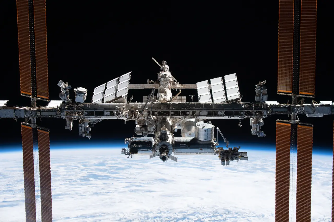
The International Space Station photographed from the SpaceX Crew Dragon Endeavour during a flyaround, November 2021.
Image: NASA (iss066e081189).

Earth orbit

Low Earth orbit

Earth orbit
Gravity
weightlessness (microgravity, or free fall)20
Radiation dose
~0.2 to ~0.5 mSv/day radiation dose (effective dose) on the ISS; ~40 to ~90 mSv per six-month mission32mSv = millisievert. The unit for radiation dose to the body. An effective dose is the whole-body dose.
Radiation protection (shielding)
Astronauts and the ISS are largely protected by Earth's magnetic field in low Earth orbit29
Contact with Earth (Earth visibility)
More than 99 percent of every orbit (Earth-orbiting missions served by NASA's Tracking and Data Relay Satellites (TDRS), not the ISS alone)21LOS = loss of signal. A gap when a spacecraft cannot communicate with the ground.NASA's own TDRS fact sheet says “more than 95 percent”; the two NASA pages do not explain the difference.16Why gaps remain on the ISS: “LOSs are caused by blockage from the earth or from the ISS structure itself”, or another space vehicle with a higher priority is using the relay. This NASA paper dates from ~1999 to 2000, so it explains why gaps happen and gives no current numbers.7Gap length in minutes: TBD, no public source found.
Time to get there
~34 hours (Crew-12, Feb 2026)27,28calc. Liftoff 5:15 a.m. EST on Feb 13, 2026 (NASA launch release) and docking 3:15 p.m. EST on Feb 14, 2026 (NASA blog): 34 hours. One crew flight; NASA says a spacecraft can arrive as soon as four hours after launching24.
Time to get home
Within 24 hours from the time that the decision to return has been made (emergency return from the ISS; a NASA design requirement for commercial crew vehicles, not Soyuz, not a measured time)15Normal return, not an emergency: Crew Dragon, Demo-2 (2020), primary opportunity “between six and 30 hours”.17Normal return, not an emergency: Soyuz MS-26 (2025), “just over three hours after undocking”.26Normal return, not an emergency: Soyuz MS-21 (2022), “less than three-and-a-half hours after undocking”.19Soyuz emergency return time: TBD, no public source found.
Sunlight (illumination fraction)
16 sunrises and sunsets per day24
Temperature
-120 to +120 °C (outside surfaces of the ISS, not the cabin)2,18NASA rule of thumb for external materials and surfaces on the ISS, not the cabin; ~16 heating and cooling cycles a day. The European Space Agency (ESA) gives up to 150 °C in sunlight down to -150 °C in shade for generic exposed low Earth orbit surfaces. Agency figures differ by surface. Not yet scored.

Science and commercial opportunities

Public statements, quoted as published; each source is named, and the speaker too where the source gives one. This project is independent and is not affiliated with or endorsed by NASA or the ISS National Laboratory, and it does not endorse any company.

Science

“We will continue to need a place to conduct research, develop technologies, train crews, and prepare for missions to the Moon and Mars.”13

NASA Administrator Jared Isaacman · NASA · Oct 9, 2026

“Space doesn't make everything better, but it can offer innovation and pathways to discovery that are not possible here on Earth.”5

Michael Roberts, Chief Scientific Officer, ISS National Laboratory · ISS National Laboratory · Jun 10, 2026

Commercial, as NASA stated it

“Industry believes it can meet the timelines and that a viable commercial marketplace exists where NASA is one customer among many.”10

NASA reporting what industry believes: NASA Administrator Jared Isaacman · NASA · Jul 6, 2026

“Commercial space stations may provide that capability while creating new opportunities for American industry and allowing NASA to concentrate more of our resources on the near-impossible missions ahead. The opportunity is significant, but the economics ultimately have to work.”13

NASA Administrator Jared Isaacman · NASA · Oct 9, 2026

Sources · 2 European Space Agency, 2020 · 5 ISS National Laboratory, 2026 · 7 Mixson, 2000 · 10 NASA, 2026 · 13 NASA, 2026 · 15 National Aeronautics and Space Administration, 2017 · 16 National Aeronautics and Space Administration, 2017 · 17 National Aeronautics and Space Administration, 2020 · 18 National Aeronautics and Space Administration, 2020 · 19 National Aeronautics and Space Administration, 2022 · 20 National Aeronautics and Space Administration, 2023 · 21 National Aeronautics and Space Administration, 2023 · 24 National Aeronautics and Space Administration, 2024 · 26 National Aeronautics and Space Administration, 2025 · 27 National Aeronautics and Space Administration, 2026 · 28 National Aeronautics and Space Administration, 2026 · 29 National Aeronautics and Space Administration, n.d. · 32 Simonsen, 2025
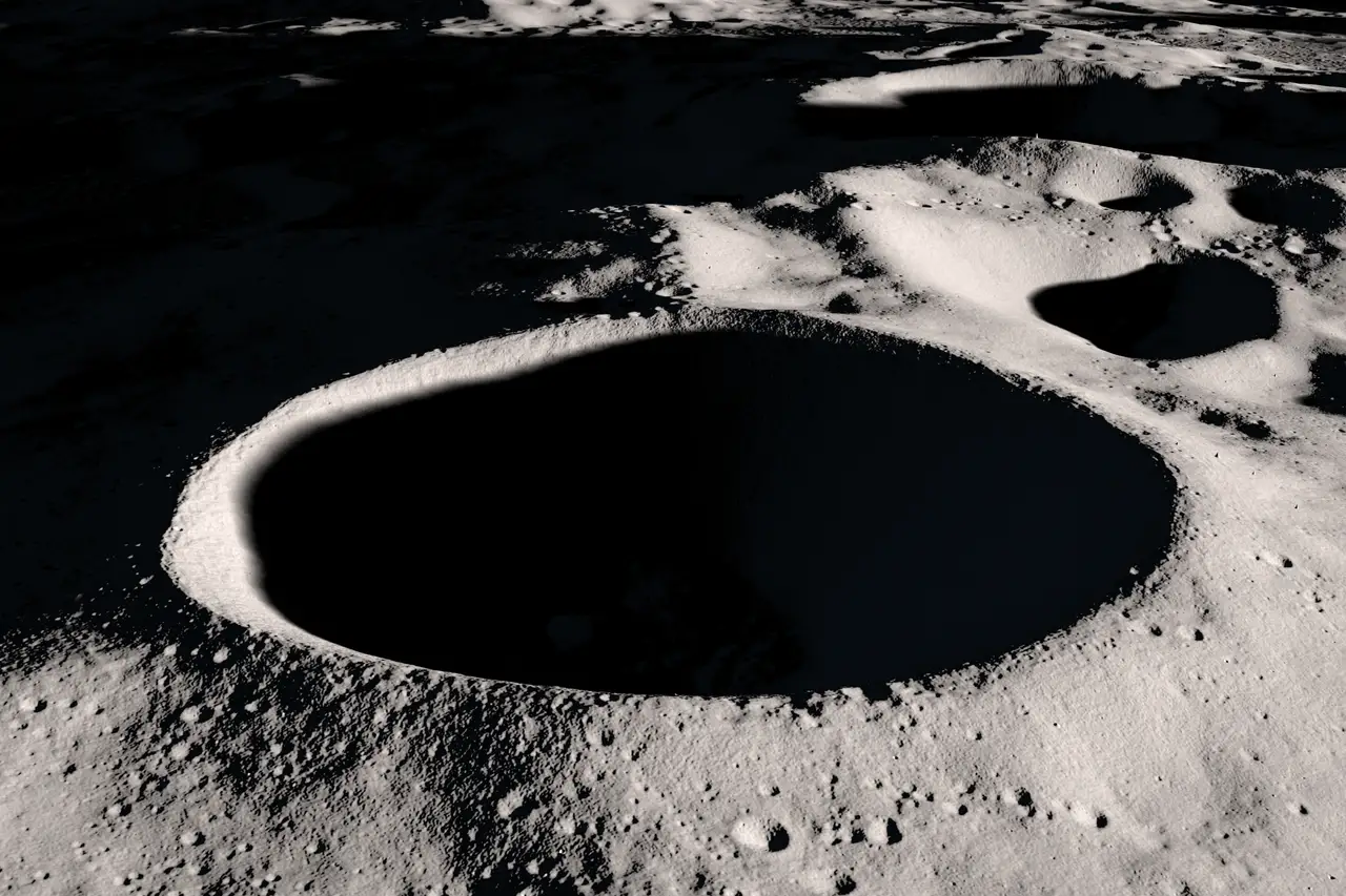
Computer-generated visualization of Shackleton crater at the Moon's south pole, built from Lunar Reconnaissance Orbiter laser altimeter data.
Image: NASA Scientific Visualization Studio (SVS 4716), a computer visualization, not a photo.

Lunar surface

Lunar south pole

Lunar surface
Gravity
1.62 m/s²22m/s² = meters per second squared. How fast a dropped object speeds up, the unit of gravitational acceleration.
Radiation dose
TBDNo measured south-pole dose was found in public sources.
Radiation protection (shielding)
TBDNo peer-reviewed or agency source for a south-pole figure for shielding by terrain was found.
Contact with Earth (Earth visibility)
Computer-modelled for Artemis candidate Sites 007 and 011 only: a direct link to Earth is possible up to ~60% of the time; a relay satellite in orbit is needed for the rest6
Time to get there
TBDNo crewed Earth-to-surface figure found in public sources.
Time to get home
TBDSurface-to-Earth time: TBD. The only public figure found assumed a Gateway staging orbit that is no longer planned.
Sunlight (illumination fraction)
78.1% to 88.0% average sunlight (illumination) at the best-lit south-pole sites (2 m above ground, 20-year average)3
Temperature
Most of the area at Artemis candidate Sites 007 and 011 is ~70 K to ~200 K6K = kelvin. A unit of temperature counted up from absolute zero, the coldest temperature possible.
Temperature (coldest estimate)
Temperature below the surface at the LCROSS (Lunar Crater Observation and Sensing Satellite) impact site is estimated at 38 K30

Science and commercial opportunities

Public statements, quoted as published; each source is named, and the speaker too where the source gives one. This project is independent and is not affiliated with or endorsed by NASA, the NASA Office of Inspector General or the Journal of Geophysical Research: Planets, and it does not endorse any company.

Science

“Its ancient terrain, distinctive lighting conditions, and areas of persistent shadow make it an important destination for scientific discovery and the future of human lunar exploration.”14

On the lunar South Pole region: NASA · Updated Sep 28, 2026

“These regions maintain cold temperatures that potentially trap and accumulate volatiles over geologic timescales.”44

On the permanently shadowed regions at the lunar south pole: Wueller et al. · Journal of Geophysical Research: Planets · Feb 27, 2026

volatiles = substances that turn to gas easily. Water is the main example; ice in cold lunar shadows is one.

Commercial, as NASA and its Inspector General stated it

“Moon Base development campaign will create an unprecedented demand of capability, significantly increasing commercial opportunities, with multiple onramps, for new and existing providers.”12

On the Moon Base at the lunar south pole: NASA · Mar 2026 (file date)

“With 17 lunar surface deliveries across multiple providers, NASA also announced new opportunities for American industry to contribute to the Moon Base.”11

On the Moon Base at the lunar south pole: NASA · Jun 30, 2026

CLPS (Commercial Lunar Payload Services) is NASA's program for buying commercial deliveries to the Moon. The two statements below cover the whole Moon, not only the south pole.

“However, CLPS vendors have had difficulty making credible business cases to potential customers and investors.”8

Hedge, covers the whole Moon: NASA Office of Inspector General · Jun 6, 2024

“Auditors also determined that the use of firm-fixed-price contracts shifted production and cost risks to the CLPS vendors, which created financial pressures for these small, relatively new companies. This contributed to one CLPS vendor’s bankruptcy and continuing market uncertainty for the others.”9

Hedge, covers the whole Moon: NASA Office of Inspector General · May 18, 2026

Sources · 3 Gläser, 2018 · 6 Kumari, 2022 · 8 NASA Office of Inspector General, 2024 · 9 NASA Office of Inspector General, 2026 · 11 NASA, 2026 · 12 NASA, 2026 · 14 NASA, 2026 · 22 National Aeronautics and Space Administration, 2024 · 30 Paige, 2010 · 44 Wueller, 2026

Method and definitions

How to read the locations

The scenes are a drawing of the cited figures. The place profiles are the record.

ISS
International Space Station. Used on this page as a reference orbit only.
Orbit tilt (inclination)
The angle between an orbit’s plane and Earth’s equator, as a source states it. On the globe it is the tilt of the ring. This page does not compute a ground track.
Altitude
Height above Earth’s surface, as a source states it, in kilometers. Spacing between rings is not to scale, so ring size is not a measured height.
Time per orbit (period)
The time for one revolution, as a source states it, in minutes. Where a source states the altitude but no period, the period is calculated from that altitude and tagged calc. (see Method). Where neither is stated, the figure is TBD.
Ground track
The path a spacecraft traces over Earth’s surface. The cited inclination is the northern and southern limit of that path. Coverage on this page restates the cited inclination. It does not compute the track or a population share.
PSR
Permanently shadowed region. Cited sources name PSRs as a reason the lunar south pole can hold water ice. This page does not state a distance from any habitat to a PSR.
Sunlight (illumination fraction)
Illumination is how much sunlight a place gets. This is the share of time a place is in sunlight. Figures here are region-level statements from the cited studies. They are not a reading at a fixed landing site.
Contact with Earth (Earth visibility)
How often a place on the Moon can see Earth for a direct link. Figures here are region-level. Site values are TBD.
calc. (calculated)
A value we worked out from cited inputs, shown in italics, with the inputs and sources named.
Source date
The date of the cited page or paper. It is part of each source's entry in the references list. Values were checked on the stated date.
Flat landing area (% of region)
The share of a candidate region where the slope is under 8° and the ground is more than 100 m from steeper slopes, the landing rule Wueller et al. (2026) apply to the Starship HLS (Human Landing System) lander (their Table 1).
Reachable ice area
The share of a region that is accessible on foot (slope 20° or less), cold (average summer surface temperature 125 K or less) and 20% or less illuminated over the 18.6-year cycle. K is kelvin, a temperature scale counted up from absolute zero; the 18.6-year cycle is the Moon’s nodal cycle, a slow turning of the Moon’s orbit plane.
Candidate region and site
A candidate region is an area a source names; here, the nine Artemis III candidate regions are the areas NASA named in October 2024 as possible landing regions for Artemis III. A site would be a fixed point inside a region. No lunar habitat on this page has a fixed site.

TBD. TBD means no source cited for this page states the figure. It does not mean the program lacks the capability. A TBD carries no source, no † and no score.

Low confidence. † marks Low confidence. High and Medium carry no mark. A TBD never carries †.

The approximation mark. Where a source gives an approximate figure, the value keeps ~. The page does not spell that mark out as a word.

Cited sources only. Every figure is a value a builder, an agency, a paper, or the press states, or a calculation from cited inputs that is tagged calc. No altitude or inclination is filled in to close a gap, and a period is either stated by a source or calculated as described under Calculated period.

The four site attributes. Percentages are shares of each region, and region sizes differ a lot (Mons Mouton Plateau is ~4,450 km² from Table 1's 564.8 km² at 12.7%, most others ~400 km²), so percentages are not like-for-like across regions. These are the nine regions NASA named in October 2024; the papers analyze many candidate landing sites inside each. The distance from the pole is calc.: it uses the latitude the USGS Gazetteer of Planetary Nomenclature gives for a named neighboring feature (not the region center) and the mean lunar radius, 1737.4 km (NASA Moon Fact Sheet). The sunlight count is calc.: our roll-up of Wueller et al. 2026, Table A2 (the maximum consecutive sunlit days of each candidate landing site, midsummers 2025 to 2032), counting the midsummers of the 8 in which at least one candidate landing site in the region is lit for 10 or more consecutive days. Calculated numbers are shown in italics with the calc. tag, apart from sourced numbers. The sites are listed in NASA's order, not ranked.

Reachable ice area. Reachable ice area is TBD for all nine regions: the only public per-region figures found are in a conference abstract, which this page does not use as a source.

Calculated period. Where a source states a station's altitude and none states its period, the period is calc.: T = 2π√((R + h)³/μ) for a circular orbit, with R = 6371 km and μ = 398,600 km³/s² from NASA's Earth Fact Sheet (μ is GM, Earth's gravitational parameter) and h the cited altitude, rounded to whole minutes (a range stays a range, and a ~ altitude keeps ~); a source-stated period always wins, and a TBD altitude leaves the period TBD.

Scores. Scoring uses 0 to 2 on closeness to the facts, review, whether a source states the value outright, how recent it is, and independent agreement. A total of 8 to 10 is High, 5 to 7 Medium and 0 to 4 Low; only Low carries †. This page shows no scores: each value shows its source, and a value not yet scored says so. A TBD is never scored or marked.

Rings. A ring is drawn only where a source states both an altitude and an inclination. The globe shows the selected habitat's ring, the ISS reference ring, and faint context rings for Orbital Reef, Haven-1, Starlab Station and Bharatiya Antariksh Station. Haven-2, Axiom Station, Thunderbird Station, Gravitics StarMax and Russian Orbital Station lack a stated altitude or inclination, so selecting one shows a note saying which is TBD and no ring. Gravitics StarMax is a module: Host station TBD. The Bharatiya Antariksh Station ring is Low confidence (†).

Reference orbit. ISS is the thin gray ring on the globe, labeled ISS. It is a reference, not one of the 13 planned habitats. The ISS is drawn as a reference ring and is not a place profile. Tiangong is not drawn or listed on this page.

The drawing. Altitude spacing is not to scale. Every ring is drawn crossing the equator at the same point (one shared line of nodes), because sources give each orbit's tilt but not where it crosses. The Moon map is the LROC WAC south-pole mosaic with the extents of the USGS navigation grids for NASA's nine candidate regions drawn on it, redrawn in the mosaic’s projection for display. No site is fixed.

This version. v1.0 · November 2026. Stations and regions: frozen, data as of 2026-10-28. Place profiles: values checked 2026-10-28; site attributes checked 2026-10-27. A later change belongs in a later version. Source dates are in the references list, and values were checked on the stated date. Builder, status, dates, crew and launch vehicle for each habitat are on Project 1 (/habitats/), which each planned habitat links to.

Terms and abbreviations
†
low confidence. A figure marked † rests on weaker evidence, such as an inference, a requirement or a single secondary source. A TBD never carries it.
1/6g
one-sixth of Earth's gravity. The fraction of Earth's gravity felt on the Moon's surface.
18.6-year cycle
the Moon's nodal cycle. A slow turning of the Moon's orbit plane that repeats every 18.6 years and changes how sunlight reaches the poles.
AI
artificial intelligence. Software that performs tasks that normally need human judgment.
AIAA
American Institute of Aeronautics and Astronautics. A professional society for aerospace.
Artemis III candidate regions
the nine areas NASA named in October 2024. Possible landing regions NASA named for Artemis III. They are candidates, not a final choice.
avg.
average. Total energy used divided by time.
AxEMU
Axiom Extravehicular Mobility Unit. Axiom Space's spacesuit.
BAS
Bharatiya Antariksh Station. India's planned space station, led by ISRO.
calc.
calculated. A value we worked out from cited inputs, shown in italics, with the inputs and sources named.
CC0
Creative Commons Zero. A public-domain dedication: the owner gives up copyright claims so anyone may reuse the work.
cont.
continuous. Power delivered without a break.
CSEP
Certified Systems Engineering Professional. A systems engineering credential awarded by the International Council on Systems Engineering (INCOSE).
ECLSS
Environmental Control and Life Support System. The equipment that supplies air and water and removes waste.
effective dose
whole-body radiation dose. A radiation dose adjusted for how sensitive each part of the body is, so one number covers the whole body.
equiv.
equivalent. Mapped to the nearest NASA project phase. The program itself may not use NASA's phases.
EVA
extravehicular activity. A spacewalk: work done outside the spacecraft, in a spacesuit.
GM (μ)
Earth's gravitational parameter. A constant that sets how strongly Earth pulls on an orbiting object. It is used to calculate the time per orbit.
GS-12
General Schedule grade 12. A federal General Schedule pay grade.
GSFC
NASA Goddard Space Flight Center. A NASA research center.
Hab
habitat. A pressurized place where crew live and work.
HALO
Habitation and Logistics Outpost. A planned crew living module for a lunar-orbit station.
HLS
Human Landing System. NASA's program for landers that carry astronauts to the Moon's surface. Starship HLS and Blue Moon are the two HLS landers in this project.
I-Hab
International Habitation Module. A planned crew living module for a lunar-orbit station.
inclination
orbit tilt. The tilt of an orbit relative to the equator.
Incln.
inclination. The tilt of an orbit relative to the equator.
INCOSE
International Council on Systems Engineering. A professional society for systems engineering.
ISRO
Indian Space Research Organisation. India's space agency.
ISS
International Space Station. The crewed station now in low Earth orbit. It is used here as a baseline for comparison and as a reference orbit.
JAXA
Japan Aerospace Exploration Agency. Japan's space agency.
K
kelvin. A unit of temperature counted up from absolute zero, the coldest temperature possible.
kW
kilowatt. A unit of power equal to a thousand watts.
kWe
kilowatts of electricity. Electrical power, as opposed to heat or other forms of power.
kWp
kilowatts peak. The most electrical power solar cells can produce in ideal conditions.
LEO
low Earth orbit. The band of orbits close to Earth where the ISS and most space stations fly.
LIFE®
Large Integrated Flexible Environment. An inflatable habitat module.
line of nodes
the line where an orbit crosses the equator plane. It marks the two points where an orbit crosses the equator. Sources give an orbit's tilt but not where it crosses.
LOS
loss of signal. A gap when a spacecraft cannot communicate with the ground.
LROC WAC
Lunar Reconnaissance Orbiter Camera, Wide Angle Camera. The camera on NASA's Lunar Reconnaissance Orbiter that took the south-pole mosaic used for the map.
m/s²
meters per second squared. How fast a dropped object speeds up, the unit of gravitational acceleration.
METNAV
meteorological and navigation. Weather and navigation systems.
MMOD
micrometeoroid and orbital debris. Tiny natural particles and human-made debris that can strike a spacecraft.
mSv
millisievert. The unit for radiation dose to the body. An effective dose is the whole-body dose.
NASA project phases
Pre-Phase A to Phase F. Pre-Phase A and A: concept. B and C: design. D: build and test. E: operations. F: closeout. equiv. means a program's own milestone has been mapped to the nearest NASA phase.
NET
no earlier than. A date marked NET is the earliest it could happen; it may be later.
nom.
nominal. While operating normally, as planned.
NRHO
near-rectilinear halo orbit. An elongated orbit around the Moon that swings close to the Moon on one side and far from it on the other.
OCHMO
NASA Office of the Chief Health and Medical Officer. The NASA office that sets health and medical standards for crew, including for drinking water.
Open-Loop
open-loop life support. Water is not recycled: stored water is used and not recovered.
PDS
NASA Planetary Data System. NASA's public archive of data from planetary missions.
PPE
Power and Propulsion Element. A planned power and propulsion module for a lunar-orbit station.
PSR
permanently shadowed region. A lunar area that never receives direct sunlight. Cited sources name these as a reason the south pole can hold water ice.
reqt.
requirement. A figure a program must meet, not a measured or designed value.
ROS
Russian Orbital Station. Russia's planned space station, a successor to the ISS.
SE
systems engineering. The discipline of designing a whole system so its parts work together.
stat.
stationary. The Lunar Cruiser's power figure is a stationary requirement, as its source data states it.
t
tonnes (metric tons). A unit of mass.
TBD
to be determined. No cited source states the figure yet. It does not mean the program lacks the capability.
TDRS
Tracking and Data Relay Satellite. A NASA relay satellite that passes signals between spacecraft in low Earth orbit and the ground.
USGS
U.S. Geological Survey. The U.S. government science agency whose maps and data this project cites.
volatiles
substances that turn to gas easily. Water is the main example; ice in cold lunar shadows is one.
Ø
diameter. The width across a round object.

How to cite this

Freeman, M. (2026). Habitat Locations (v1.0, November 2026). Mindset in Space. https://www.mindsetinspace.com/locations/

To point to one entry, link to it directly, for example https://www.mindsetinspace.com/locations/#place-lunar_south_pole.

Sources

References

44 public sources in APA style, listed alphabetically. Superscript numbers point here. No tertiary source is in the list.

  1. Davenport, J. (2021, October 27). Blue Origin, Sierra Space, and Boeing announce Orbital Reef. NASASpaceFlight.com. https://www.nasaspaceflight.com/2021/10/announce-orbital-reef/Used for: Orbital Reef altitude, inclination, rationale. Tier: press.
    Show quote

    Used for: Orbital Reef altitude, inclination, rationale. “would use a 500-kilometer altitude orbit inclined 51.6 degrees to the equator. … This inclination would take Orbital Reef over most of the world, including launch sites in the United States, Kazakhstan, China, Japan, India, and South America.”

  2. European Space Agency. (2020, June 4). Orbital space ageing tests offered for space age materials. https://www.esa.int/Enabling_Support/Space_Engineering_Technology/Orbital_space_ageing_tests_offered_for_space_age_materialsUsed for: Low Earth orbit (LEO): Temperature. Tier: agency. Checked 2026-10-28.
    Show quote

    Used for: Low Earth orbit (LEO): Temperature. “Ongoing sudden shifts in temperature from up to 150 degrees C in sunlight down to -150 degrees C in the shade may cause cracking, misalignment, even buckling.”

  3. Gläser, P., Oberst, J., Neumann, G. A., Mazarico, E., Speyerer, E. J., & Robinson, M. S. (2018). Illumination conditions at the lunar poles: Implications for future exploration. Planetary and Space Science, 162, 170–178. https://ntrs.nasa.gov/api/citations/20170007365/downloads/20170007365.pdfUsed for: Illumination % at best south-pole sites (LOLA). Tier: peer-reviewed.
    Show quote

    Used for: Illumination % at best south-pole sites (LOLA). “The maximum average illumination of 88.0% is now found at the south pole at Connecting Ridge (C1) (Fig. 4b). … The maximum average illumination levels are 71.6% and 78.1% and the longest solar visibility is found to be 75.1% and 82.0% respectively.”

    Source location: Table 2, south pole, 2 m above ground.

  4. India Today Science Desk. (2024, July 10). Indian space station to mirror ISS orbit: Why it’s a strategic masterstroke. India Today. https://www.indiatoday.in/science/story/bharatiya-antariksh-station-isro-nasa-iss-orbit-inclination-science-2564781-2024-07-10Used for: BAS inclination and rationale (Low: single press source, no ISRO document). Tier: press.
    Show quote

    Used for: BAS inclination and rationale (Low: single press source, no ISRO document). “The Indian Space Research Organisation (Isro) has revealed that the station will orbit at a 51.5-degree inclination, nearly identical to the International Space Station's (ISS) 51.6-degree path.”

  5. ISS National Laboratory. (2026, June 10). ISS Research Drives Innovation and Fuels Commercial Space Economy. https://issnationallab.org/iss360/iss-research-commercial-leo-economy-innovation/Used for: LEO: Science and commercial opportunities. Tier: agency. Checked 2026-10-27.
    Show quote

    Used for: LEO: Science and commercial opportunities. “Space doesn't make everything better, but it can offer innovation and pathways to discovery that are not possible here on Earth.”

  6. Kumari, N., Bretzfelder, J. M., Ganesh, I., Lang, A., & Kring, D. A. (2022). Surface conditions and resource accessibility at potential Artemis landing sites 007 and 011. The Planetary Science Journal, 3(9), 224. https://doi.org/10.3847/PSJ/ac88c2Used for: Earth visibility ~50–60%; relay need; HLS slope requirement; temperature range. Tier: peer-reviewed.
    Show quote

    Used for: Earth visibility ~50–60%; relay need; HLS slope requirement; temperature range. “it might be possible to communicate directly to Earth from the landing regions of both sites for 60% of the time. For the rest of the time, and/or from other regions an orbital relay would be needed for communication. … the HLS shall provide a vertical orientation of 0°–8° (threshold) and 0°–5° (goal) from local vertical for surface operations. … the majority of area within these sites lies approximately between 70 K and 200 K”

  7. Mixson. (2000). ISS high-rate data recorder for TDRS outages [NASA technical paper]. NASA Technical Reports Server, 19990100661. https://ntrs.nasa.gov/api/citations/19990100661/downloads/19990100661.pdfUsed for: Low Earth orbit (LEO): Contact with Earth (Earth visibility). Tier: agency. Checked 2026-10-28.
    Show quote

    Used for: Low Earth orbit (LEO): Contact with Earth (Earth visibility). “there are periods during every orbit when the onboard antennas cannot communicate with a TDRS. These times are referred to as Loss of Signal (LOS) periods. LOSs are caused by blockage from the earth or from the ISS structure itself. LOSs are also possible because another space vehicle with a higher priority is using the TDRS in view.”

  8. NASA Office of Inspector General. (2024, June 6). NASA's Commercial Lunar Payload Services Initiative (report IG-24-013). https://oig.nasa.gov/wp-content/uploads/2024/06/final-report-ig-24-013-nasas-commercial-lunar-payload-services-initiative.pdfUsed for: Lunar south pole (with the nine Artemis III candidate regions): Science and commercial opportunities. Tier: agency. Checked 2026-10-28.
    Show quote

    Used for: Lunar south pole (with the nine Artemis III candidate regions): Science and commercial opportunities. “However, CLPS vendors have had difficulty making credible business cases to potential customers and investors.”

  9. NASA Office of Inspector General. (2026, May 18). Examining the Commercial Lander Services Powering NASA's Return to the Moon. https://oig.nasa.gov/news/examining-the-commercial-lander-services-powering-nasas-return-to-the-moon/Used for: Lunar south pole (with the nine Artemis III candidate regions): Science and commercial opportunities. Tier: agency. Checked 2026-10-28.
    Show quote

    Used for: Lunar south pole (with the nine Artemis III candidate regions): Science and commercial opportunities. “Auditors also determined that the use of firm-fixed-price contracts shifted production and cost risks to the CLPS vendors, which created financial pressures for these small, relatively new companies. This contributed to one CLPS vendor’s bankruptcy and continuing market uncertainty for the others.”

  10. NASA. (2026, July 6). NASA Seeks Industry Input on Second Phase of Commercial Space Stations. https://www.nasa.gov/humans-in-space/commercial-space/nasa-seeks-industry-input-on-second-phase-of-commercial-space-stations/Used for: LEO: Science and commercial opportunities. Tier: agency. Checked 2026-10-27.
    Show quote

    Used for: LEO: Science and commercial opportunities. “Industry believes it can meet the timelines and that a viable commercial marketplace exists where NASA is one customer among many.”

  11. NASA. (2026, June 30). NASA Awards More Moon Base Science, Previews New Opportunities (NASA news release 26-053). https://www.nasa.gov/news-release/nasa-awards-more-moon-base-science-previews-new-opportunities/Used for: Lunar south pole (with the nine Artemis III candidate regions): Science and commercial opportunities. Tier: agency. Checked 2026-10-28.
    Show quote

    Used for: Lunar south pole (with the nine Artemis III candidate regions): Science and commercial opportunities. “With 17 lunar surface deliveries across multiple providers, NASA also announced new opportunities for American industry to contribute to the Moon Base.”

  12. NASA. (2026, March). NASA Unveils Plan to Establish America's First Moon Base (PDF). https://www.nasa.gov/wp-content/uploads/2026/03/building-the-moon-base-1.pdfUsed for: Lunar south pole (with the nine Artemis III candidate regions): Science and commercial opportunities. Tier: agency. Checked 2026-10-28.
    Show quote

    Used for: Lunar south pole (with the nine Artemis III candidate regions): Science and commercial opportunities. “Moon Base development campaign will create an unprecedented demand of capability, significantly increasing commercial opportunities, with multiple onramps, for new and existing providers.”

  13. NASA. (2026, October 9). NASA Seeks US Industry Plans for Commercial Space Stations (NASA news release RELEASE26-086). https://www.nasa.gov/news-release/nasa-seeks-us-industry-plans-for-commercial-space-stations/Used for: LEO: Science and commercial opportunities. Tier: agency. Checked 2026-10-27.
    Show quote

    Used for: LEO: Science and commercial opportunities. “We will continue to need a place to conduct research, develop technologies, train crews, and prepare for missions to the Moon and Mars.”

  14. NASA. (2026, September 28). The Lunar South Pole Region. https://www.nasa.gov/reference/moonbase-environment/Used for: Lunar south pole (with the nine Artemis III candidate regions): Science and commercial opportunities. Tier: agency. Checked 2026-10-28.
    Show quote

    Used for: Lunar south pole (with the nine Artemis III candidate regions): Science and commercial opportunities. “Its ancient terrain, distinctive lighting conditions, and areas of persistent shadow make it an important destination for scientific discovery and the future of human lunar exploration.”

  15. National Aeronautics and Space Administration, Commercial Crew Program. (2017, September 6). ISS crew transportation and services requirements document (CCT-REQ-1130, Rev. F). NASA Technical Reports Server, 20180006508. https://ntrs.nasa.gov/api/citations/20180006508/downloads/20180006508.pdfUsed for: Low Earth orbit (LEO): Time to get home. Tier: agency. Checked 2026-10-28.
    Show quote

    Used for: Low Earth orbit (LEO): Time to get home. “The CTS shall provide emergency return of all CTS-delivered crewmembers from the ISS within 24 hours from the time that the decision to return has been made.”

  16. National Aeronautics and Space Administration. (2017). Tracking and Data Relay Satellite (TDRS) fact sheet (NP-2017-04). https://www.nasa.gov/wp-content/uploads/2022/04/tdrsfactsheet_3.pdfUsed for: Low Earth orbit (LEO): Contact with Earth (Earth visibility). Tier: agency. Checked 2026-10-28.
    Show quote

    Used for: Low Earth orbit (LEO): Contact with Earth (Earth visibility). “TDRS increased available coverage from 15 percent to more than 95 percent.”

  17. National Aeronautics and Space Administration. (2020, July 24). Top 10 things to know for NASA's SpaceX Demo-2 return. https://www.nasa.gov/humans-in-space/top-10-things-to-know-for-nasas-spacex-demo-2-return/Used for: Low Earth orbit (LEO): Time to get home. Tier: agency. Checked 2026-10-28.
    Show quote

    Used for: Low Earth orbit (LEO): Time to get home. “Return time for Behnken and Hurley will vary depending on the undock and splashdown opportunities chosen, with the primary opportunity taking between six and 30 hours.”

  18. National Aeronautics and Space Administration. (2020, September). A researcher's guide to: Space environmental effects (Rev. ed.). ISS Research Integration Office. https://www.nasa.gov/wp-content/uploads/2022/06/researchers-guide-space-environment-effects.pdfUsed for: Low Earth orbit (LEO): Temperature. Tier: agency. Checked 2026-10-28.
    Show quote

    Used for: Low Earth orbit (LEO): Temperature. “A rule of thumb for these cyclic temperature variations is ‑120°C to +120°C, but high solar absorptance with low infrared emittance will contribute to greater temperature swings.”

  19. National Aeronautics and Space Administration. (2022, September 29). Three Soyuz crewmates return to Earth, finish station mission [Space station blog]. https://www.nasa.gov/blogs/spacestation/2022/09/29/three-soyuz-crewmates-return-to-earth-finish-station-mission/Used for: Low Earth orbit (LEO): Time to get home. Tier: agency. Checked 2026-10-28.
    Show quote

    Used for: Low Earth orbit (LEO): Time to get home. “less than three-and-a-half hours after undocking from the space station”

  20. National Aeronautics and Space Administration. (2023, July 25). What is microgravity? NASA Glenn Research Center [Page modified; published 2009, February 13]. https://www.nasa.gov/centers-and-facilities/glenn/what-is-microgravity/Used for: Low Earth orbit (LEO): Gravity. Tier: agency. Checked 2026-10-28.
    Show quote

    Used for: Low Earth orbit (LEO): Gravity. “The condition of microgravity comes about whenever an object is in free fall.”

  21. National Aeronautics and Space Administration. (2023, July 26). TDRS: An era of continuous space communications [Page modified; published 2017, August 16]. https://www.nasa.gov/missions/tdrs/tdrs-an-era-of-continuous-space-communications/Used for: Low Earth orbit (LEO): Contact with Earth (Earth visibility). Tier: agency. Checked 2026-10-28.
    Show quote

    Used for: Low Earth orbit (LEO): Contact with Earth (Earth visibility). “With the construction of the Guam Remote Ground Terminal, declared operational in 1998, the ZOE was closed and Earth-orbiting mission coverage increased to more than 99 percent of every orbit.”

  22. National Aeronautics and Space Administration. (2024, January 11). Moon fact sheet. NASA Space Science Data Coordinated Archive. https://nssdc.gsfc.nasa.gov/planetary/factsheet/moonfact.htmlUsed for: Lunar south pole (with the nine Artemis III candidate regions): Gravity. Tier: agency.
    Show quote

    Used for: Lunar south pole (with the nine Artemis III candidate regions): Gravity. “Surface gravity (m/s2) 1.62 9.80 0.165”

  23. National Aeronautics and Space Administration. (2024, January 11). Moon Fact Sheet. NASA Space Science Data Coordinated Archive. https://nssdc.gsfc.nasa.gov/planetary/factsheet/moonfact.htmlUsed for: Calculated distance from the lunar pole: the mean lunar radius. Tier: agency. Checked 2026-10-29.
    Show quote

    Used for: Calculated distance from the lunar pole: the mean lunar radius. “Volumetric mean radius (km) 1737.4”

  24. National Aeronautics and Space Administration. (2024, July 16). Space station facts and figures [Page modified]. https://www.nasa.gov/international-space-station/space-station-facts-and-figuresUsed for: Low Earth orbit (LEO): Sunlight (illumination fraction). Tier: agency. Checked 2026-10-28.
    Show quote

    Used for: Low Earth orbit (LEO): Sunlight (illumination fraction). “In 24 hours, the space station makes 16 orbits of Earth, traveling through 16 sunrises and sunsets. … A spacecraft can arrive at the space station as soon as four hours after launching from Earth.”

  25. National Aeronautics and Space Administration. (2024, November 15). Earth Fact Sheet. NASA Space Science Data Coordinated Archive. https://nssdc.gsfc.nasa.gov/planetary/factsheet/earthfact.htmlUsed for: Calculated orbital period: Earth's mean radius and GM. Tier: agency. Checked 2026-10-29.
    Show quote

    Used for: Calculated orbital period: Earth's mean radius and GM. “Volumetric mean radius (km) 6371.000 … GM (x 10^6 km^3/s^2) 0.39860”

  26. National Aeronautics and Space Administration. (2025, April 19). Astronaut returns to Earth on 70th birthday with Soyuz crew [Space station blog]. https://www.nasa.gov/blogs/spacestation/2025/04/19/astronaut-returns-to-earth-on-70th-birthday-with-soyuz-crew/Used for: Low Earth orbit (LEO): Time to get home. Tier: agency. Checked 2026-10-28.
    Show quote

    Used for: Low Earth orbit (LEO): Time to get home. “The Soyuz MS-26 spacecraft descends to a parachute-assisted landing in Kazakhstan just over three hours after undocking from the International Space Station.”

  27. National Aeronautics and Space Administration. (2026, February 13). NASA's SpaceX Crew-12 launches to International Space Station. https://www.nasa.gov/news-release/nasas-spacex-crew-12-launches-to-international-space-station/Used for: Low Earth orbit (LEO): Time to get there. Tier: agency.
    Show quote

    Used for: Low Earth orbit (LEO): Time to get there. “lifts off at 5:15 a.m. EST, Feb. 13, 2026”

  28. National Aeronautics and Space Administration. (2026, February 14). SpaceX Crew-12 docks to station, beginning long-duration mission. https://www.nasa.gov/blogs/spacestation/2026/02/14/spacex-crew-12-docks-to-station-beginning-long-duration-mission/Used for: Low Earth orbit (LEO): Time to get there. Tier: agency.
    Show quote

    Used for: Low Earth orbit (LEO): Time to get there. “docked with the orbiting complex at 3:15 p.m. EST”

  29. National Aeronautics and Space Administration. (n.d.). Space faring: The radiation challenge [Educator guide]. https://www.nasa.gov/wp-content/uploads/2017/04/radiationchallenge.pdfUsed for: Low Earth orbit (LEO): Radiation protection (shielding). Tier: agency.
    Show quote

    Used for: Low Earth orbit (LEO): Radiation protection (shielding). “In addition, astronauts and the ISS itself are largely protected by the Earth's magnetic field because it is in low Earth orbit.”

  30. Paige, D. A., Siegler, M. A., Zhang, J. A., Hayne, P. O., Foote, E. J., Bennett, K. A., ... Lucey, P. G. (2010). Diviner Lunar Radiometer observations of cold traps in the Moon's south polar region. Science, 330(6003), 479-482. https://doi.org/10.1126/science.1187726Used for: Lunar south pole (with the nine Artemis III candidate regions): Temperature. Tier: peer-reviewed.
    Show quote

    Used for: Lunar south pole (with the nine Artemis III candidate regions): Temperature. “subsurface temperatures are estimated to be 38 kelvin”

  31. Press Trust of India. (2025, August 22). ISRO unveils model of Bharatiya Antariksh Station. The Indian Express. https://indianexpress.com/article/india/isro-unveils-model-of-bharatiya-antariksh-station-10205494/Used for: BAS altitude. Tier: press.
    Show quote

    Used for: BAS altitude. “The BAS-01 module is expected to weigh 10 tonnes and will be placed in a low earth orbit at 450 km above the earth.”

  32. Simonsen, Zawaski, & Weeks. (2025). Moon 2 Mars space radiation protection: 'Buying down' risks to crew [Draft paper]. NASA Technical Reports Server, 20250006168. https://ntrs.nasa.gov/api/citations/20250006168/downloads/ASCEND%20Simonsen%20draft%201.pdfUsed for: Low Earth orbit (LEO): Radiation dose. Tier: agency.
    Show quote

    Used for: Low Earth orbit (LEO): Radiation dose. “On the International Space Station (ISS), effective doses accumulate at a rate of approximately 0.2 to 0.5 mSv/day, averaging between ~40 and 90 mSv during a typical six-month mission [3].”

  33. Starlab Space. (n.d.). Space station. https://starlab-space.com/space-station/Used for: Starlab altitude, inclination. Tier: builder.
    Show quote

    Used for: Starlab altitude, inclination. “Altitude: 500 km Inclination: 45° circular orbit Single launch”

  34. Starlab Space. (n.d.-b). Starlab payload handbook. https://starlab-space.com/wp-content/uploads/Starlab-Payload-Handbook-Main-file-.pdfUsed for: Starlab altitude, inclination (second builder doc). Tier: builder.
    Show quote

    Used for: Starlab altitude, inclination (second builder doc). “Orbits Earth at 500 km with a 45° inclination”

  35. TASS. (2026, February 19). Deployment of Russian orbital station planned to begin in 2028 — first deputy premier. https://tass.com/science/2089295Used for: ROS inclination, rationale, 2028 start. Tier: press.
    Show quote

    Used for: ROS inclination, rationale, 2028 start. “Plans have long been voiced to launch ROS into a polar orbit with an inclination of about 97 degrees. Russian First Deputy Prime Minister Denis Manturov said in December 2025 that the inclination of 51.6 degrees has been approved”

  36. U.S. Geological Survey. (n.d.). Gazetteer of Planetary Nomenclature: Cabeus B (satellite feature of Cabeus). Astrogeology Science Center. https://planetarynames.wr.usgs.gov/Feature/8058Used for: site-peak-near-cabeus-b: Distance from the pole. Tier: agency.
    Show quote

    Used for: site-peak-near-cabeus-b: Distance from the pole. “Center Latitude -82.26 °, Center Longitude -54.58 ° (Planetographic, +East)”

  37. U.S. Geological Survey. (n.d.). Gazetteer of Planetary Nomenclature: de Gerlache (crater). Astrogeology Science Center. https://planetarynames.wr.usgs.gov/Feature/1439Used for: site-de-gerlache-rim-2: Distance from the pole. Tier: agency.
    Show quote

    Used for: site-de-gerlache-rim-2: Distance from the pole. “Center Latitude -88.48 °, Center Longitude -88.34 ° (Planetographic, +East)”

  38. U.S. Geological Survey. (n.d.). Gazetteer of Planetary Nomenclature: Haworth. Astrogeology Science Center. https://planetarynames.wr.usgs.gov/Feature/14502Used for: site-haworth: Distance from the pole. Tier: agency.
    Show quote

    Used for: site-haworth: Distance from the pole. “Center Latitude -86.90 °, Center Longitude -4.00 ° (Planetographic, +East)”

  39. U.S. Geological Survey. (n.d.). Gazetteer of Planetary Nomenclature: Mons Malapert. Astrogeology Science Center. https://planetarynames.wr.usgs.gov/Feature/16338Used for: site-malapert-massif: Distance from the pole. Tier: agency.
    Show quote

    Used for: site-malapert-massif: Distance from the pole. “Center Latitude -85.98 °, Center Longitude -1.67 ° (Planetographic, +East)”

  40. U.S. Geological Survey. (n.d.). Gazetteer of Planetary Nomenclature: Mons Mouton. Astrogeology Science Center. https://planetarynames.wr.usgs.gov/Feature/16070Used for: site-mons-mouton-plateau: Distance from the pole. Tier: agency.
    Show quote

    Used for: site-mons-mouton-plateau: Distance from the pole. “Center Latitude -84.60 °, Center Longitude 31.00 ° (Planetographic, +East)”

  41. U.S. Geological Survey. (n.d.). Gazetteer of Planetary Nomenclature: Nobile (crater). Astrogeology Science Center. https://planetarynames.wr.usgs.gov/Feature/4321Used for: site-nobile-rim-1: Distance from the pole. Tier: agency.
    Show quote

    Used for: site-nobile-rim-1: Distance from the pole. “Center Latitude -85.28 °, Center Longitude 53.27 ° (Planetographic, +East)”

  42. U.S. Geological Survey. (n.d.). Gazetteer of Planetary Nomenclature: Slater (crater). Astrogeology Science Center. https://planetarynames.wr.usgs.gov/Feature/15325Used for: site-slater-plain: Distance from the pole. Tier: agency.
    Show quote

    Used for: site-slater-plain: Distance from the pole. “Center Latitude -88.08 °, Center Longitude 111.29 ° (Planetographic, +East)”

  43. Vast. (n.d.-a). Haven-1. https://www.vastspace.com/haven-1Used for: Haven-1 altitude, inclination; Falcon 9 + Dragon. Tier: builder.
    Show quote

    Used for: Haven-1 altitude, inclination; Falcon 9 + Dragon. “orbit: … 51.6°, 425 km”

  44. Wueller, L., Berger, L. M., Christopher, H., Sugimoto, K., Thaker, A. D., Carton, L., Jo, W., Lee, S., Pedrelli, R., Sanchez, P., & Kring, D. A. (2026). Assessing potential landing sites with favorable illumination and accessible, potentially volatile-rich permanently shadowed regions within Artemis candidate landing regions. Journal of Geophysical Research: Planets, 131(3), e2025JE009434. https://doi.org/10.1029/2025JE009434Used for: Per-region setting, flat-enough area (Table 1), cold shadow within 2 km (Table 3). Tier: peer-reviewed.
    Show quote

    Used for: Per-region setting, flat-enough area (Table 1), cold shadow within 2 km (Table 3). “Slater Plain (SP) is located ∼20 km northeast of Slater crater on the lunar farside (Figure 1; NASA, 2024). Among the 16 CLRs, SP stands out with the highest proportion of terrain (19.3% or 77 km 2; Table 1) that meets the HLS slope requirement.”